Saturday, 2017 March 18
 Ahhh spontaneity… well… that, Spring Break and the fact that my friend Ralph had been waylaid by minor mechanical issues and was still in the US. (See previous post: Annapolis to Norfolk Sailing Adventure) – what’s a lady to do? Well go sailing of course! After a quick phone call to Ralph to work out the details, an online ticket via Orbitz – gotta love the internet! – I was on my way to BWI to catch the red-eye to Fort Lauderdale where Ralph and S.V. Escape Plan (his Ericson 38) were waiting.
I arrived in Fort Lauderdale, FL. around 01:00 and Ralph met me with the dingy near the harbour police station. Once on board the adrenalin (and caffein) were wearing off and I crashed in the rear cabin to get some sleep before we broke anchor to head for the keys.
Sunday Afternoon
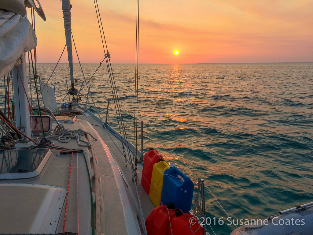
Broke anchor today to head for the Keys with an overnight stopover in Miami. Getting out of Fort Lauderdale was crazy with all of the traffic, but once we were out in the ocean the sailing was great! We arrived in Miami after dark and found a quiet cove to drop anchor.
Monday and Tuesday: Sailing to Key West
Key West is one of my favourite places to visit. It’s the US’s only tropical island that you can drive to – and I have many times. So, when the opportunity presented itself to sail there… yeehaw! Our plan was to head down to the Dry Tortugas see Fort Jefferson then make our way north to Miami where I would catch my flight back home. Unfortunately the weather did not cooperate and we ended up doing a shorter trip to some of the outlying keys below Key West.
“Key West (Spanish: Cayo Hueso) is an island and city in the Straits of Florida on the North American continent, at the southwesternmost end of the roadway through the Florida Keys in the state of Florida, United States. Key West is the southernmost city in the contiguous United States. The island is about 4 miles (6.4 km) long and 1 mile (1.6 km) wide, with a total land mass of 4.2 square miles (11 km2). Duval Street, its main street, is 1.1 miles (1.8 km) in length in its 14-block-long crossing from the Gulf of Mexico to the Straits of Florida and the Atlantic Ocean. Key West is about 95 miles (153 km) north of Cuba at their closest points” – Wikipedia

Wednesday: Boca Grande and the Marquesas
Boca Grande Key is an island in the Florida Keys in Monroe County, Florida, United States. It is within the boundaries of the Key West National Wildlife Refuge. It is 183 acres (74 ha) in size. Located in the Outlying Islands of the Florida Keys, it is the largest and westernmost of the Mule Keys that are 9 miles (15 km) west of Key West. – Adapted from Wikipedia

The Marquesas Keys (not to be confused with the Marquesas Islands) form an uninhabited island group about 20 miles (32 km) west of Key West, 4 miles (6 km) in diameter, and largely covered by mangrove forest. They are an unincorporated area of Monroe County, Florida and belong to the Lower Keys Census County Division. They are protected as part of the Key West National Wildlife Refuge, but were used for target practice by the military as recently as 1980. The total area, including the lagoon, measures 29.37 km2 (11.34 sq mi). The land area, according to the United States Census Bureau, is 6.58 km2 (2.54 sq mi) (exactly 6,579,703 m²), the water area 0.17 km2 (0.066 sq mi) (165,744 m²), giving a combined area of 6.75 km2 (2.61 sq mi) (6,745,447 m²), not counting water areas with connection to the open sea, but including small landlocked lakes on the Keys. The group is located at coordinates 24°34′19″N 82°07′10″W. The islands are part of the Florida Keys, separated from the rest of the Florida Keys, which are farther east, by the Boca Grande Channel, which is 6 miles (9.7 km) wide until Boca Grande Key, the westernmost of the Mule Keys. Only the Dry Tortugas are farther west, 36 miles (58 km) west of the Marquesas Keys. The central lagoon is called Mooney Harbor. The northernmost key is the largest and has a strip of sandy beach free of mangrove. In the past it was known as “Entrance Key”. It surrounds the lagoon in the north and east. Adjoining in the south are smaller keys such as Gull Keys, Mooney Harbor Key, and finally about four unnamed keys in the southwest corner of the group. Older charts show that two of these keys once were named “Button Island” and “Round Island”.
– Adapted from Wikipedia

Wednesday night / Thursday Morning: Heading back to Key West
Friday: Hanging out in Key west
Saturday: Homeward Bound


Location: Mallory Square, Key West, Florida, United States, North America
Altitude: 2.00 m